LiDAR Surveying: A Safe Future Through Hazard Analysis
Venturing into the realm of geohazard analysis, the words of John Muir resonate profoundly: 'The clearest way into the Universe is through a forest wilderness.' In the pursuit of understanding and safeguarding vulnerable regions, LiDAR surveying has emerged as the clearest lens to unlock the mysteries of geologically hazardous areas.
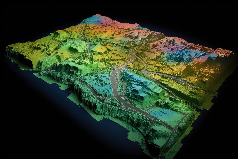
As technology continues to revolutionize the world of surveying, LiDAR's powerful capabilities have garnered immense attention for its unrivaled precision and efficiency. By harnessing laser pulses to craft detailed 3D models, LiDAR surveying has become invaluable, empowering researchers and geologists to proactively detect and manage potential threats. This article delves into the transformative impact of LiDAR surveying, highlighting its pivotal role in shaping a safer and more resilient future for communities.
Peering Into The Earth's Secrets: The Power Of LiDAR Surveying
In modern geospatial technologies, LiDAR surveying is a game-changing innovation that has revolutionized hazard analysis and land assessment. This cutting-edge solution has unlocked the hidden secrets of our planet's terrains by utilizing advanced laser scanning techniques. As we delve deeper into this groundbreaking approach, we uncover its incredible time, cost and efficiency advantages, along with seamless delivery and training methodologies shaping a safer future.
Time Optimization: Swift Action In The Face Of Danger
Traditional geological surveys were often time-consuming and labor-intensive, leading to delays in identifying and addressing potential hazards. However, accurate LiDAR surveying has transformed this landscape, drastically reducing the time required for data collection and analysis. By quickly scanning vast terrains from above, LiDAR surveying enables rapid high-resolution data acquisition, expediting hazard identification. This swift action in the face of danger has proven instrumental in preventing catastrophic events and ensuring the safety of local communities.
Cost-Effectiveness And Efficiency: Empowering Sustainable Solutions
Cost considerations have always been a major factor in any surveying project. By effortlessly covering vast areas in a single flight and producing comprehensive data, LiDAR surveying has remarkably slashed expenses related to field surveys and manpower. Traditional ground-based surveys often require extensive resources and equipment, but LiDAR surveying minimizes these requirements, making it a cost-effective alternative. The efficiency gains from LiDAR surveying translate into more opportunities for researchers and authorities to invest in sustainable geohazard management solutions.
Seamless Delivery: A Comprehensive Geospatial Toolkit
The success of any geohazard analysis hinges on the accessibility and usability of data. LiDAR surveying and advancements in geospatial technology offer a seamless delivery mechanism for the gathered data. The high-density point cloud and detailed terrain models generated through LiDAR surveying provide geologists and planners with a comprehensive toolkit to explore, analyze and visualize hazardous areas in unprecedented detail. This invaluable data resource ensures decision-makers have the information to devise well-informed risk mitigation and disaster preparedness strategies.
Empowering Minds: Harnessing LiDAR Surveying's Potential Through Training
Introducing cutting-edge technology without proper training can hinder its full potential. Experts have developed comprehensive training programs to equip researchers, geologists and surveyors with the knowledge and skills to harness the power of accurate LiDAR surveying effectively. These specialized training initiatives ensure that experts can interpret LiDAR data accurately, extract meaningful insights and apply them to real-world scenarios. Empowered with the proficiency to interpret and act upon LiDAR-generated data, professionals can confidently steer toward a safer and more resilient future.
The Paradigm Shift: LiDAR Surveying Redefines Geohazard Analysis
LiDAR surveying has undeniably catalyzed a paradigm shift in geohazard analysis. This innovative solution has transcended traditional limitations by employing state-of-the-art technology, revolutionizing time, cost and efficiency considerations. The seamless delivery of comprehensive geospatial data has empowered researchers and decision-makers to make informed choices to protect communities from potential hazards. Experts have honed their skills through dedicated training, unleashing the full potential of LiDAR surveying and its impact on geohazard management.
Empower Your Projects With Precision And Innovation
Experience the excellence of Carroll Surveying & Mapping - Your partner for precision, innovation and unparalleled results!
Let our expert team elevate your projects to new heights with cutting-edge technology and unwavering dedication to LiDAR surveying.
Contact us today for a consultation and discover how we can revolutionize your surveying and mapping needs.
Trust us to deliver accurate data, efficient solutions and peace of mind for your next venture.